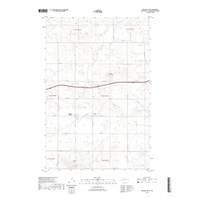
2018 Map of Sentinel Butte
USGS Topo · Published 2018About this map
Sentinel Butte sits at a geographic crossroads in western North Dakota, where the high plains break into the distinctive landforms of the badlands. The settlement of Sentinel Butte lies south of the interstate corridor, positioned between the prominent rise of its namesake landform to the south and Camels Hump Butte to the north. This area serves as a primary drainage for local waterways including Andrews Cr and Knutson Cr, which carve through the high prairie. Local history is anchored by the Saint Michaels Cem and the small-scale recreational hub at Camels Hump Lake. The map reveals a transition from traditional township grid roads, such as Square Butte Rd and Camel Hump Rd, to the more modern transportation infrastructure of the Northern Plains.
Find a feature on this map
27 named features on this map. Tap any name to fly to it.
Don’t see what you’re looking for? This feature index may not catch every label — zoom into the map to look around manually.
Map Details
Editions of this 2018 Sentinel Butte Map
This is the sole edition of this map. No revisions or reprints were ever made.
Other maps of this area

1953 · Dickinson
USGS Topo · 1:250,000

1953 · Watford City
USGS Topo · 1:250,000

1957 · Dickinson
USGS Topo · 1:250,000

1957 · Watford City
USGS Topo · 1:250,000

1967 · Watford City
USGS Topo · 1:250,000

1974 · West Twin Butte
USGS Topo · 1:24,000
1974 · Hootowl Creek SW
USGS Topo · 1:24,000

1974 · Wannagan Creek West
USGS Topo · 1:24,000

1979 · Sentinel Butte SE
USGS Topo · 1:24,000
1979 · Buffalo Gap Campground
USGS Topo · 1:24,000