
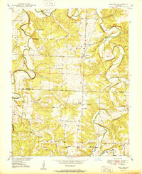
1980 Map of Sentinel
USGS Topo · Published 1982About this map
Pomme De Terre Lake dominates this orthophotoquad, its irregular fingers and coves cutting deeply into the Hickory County countryside. This 1980 aerial survey captures the shoreline of the reservoir, illustrating the impact of water management on the local geography. Small settlements and rural junctions like Pittsburg and Adonis remain as focal points for the surrounding community, while Sentinel sits further east near the drainage of Huckaby Creek.
Find a feature on this map
9 named features on this map. Tap any name to fly to it.
Don’t see what you’re looking for? This feature index may not catch every label — zoom into the map to look around manually.
Map Details
Editions of this 1980 Sentinel Map
This is the sole edition of this map. No revisions or reprints were ever made.
Other maps of this area

1884 · Bolivar
USGS Topo · 1:125,000

1892 · Bolivar
USGS Topo · 1:125,000

1942 · Elkton
USGS Topo · 1:24,000

1949 · Elkton
USGS Topo · 1:24,000

1949 · Sentinel
USGS Topo · 1:24,000

1950 · Elkton
USGS Topo · 1:24,000
1950 · Sentinel
USGS Topo · 1:24,000
1950 · Buffalo NW
USGS Topo · 1:24,000
1950 · Polk
USGS Topo · 1:24,000
1950 · Urbana
USGS Topo · 1:24,000