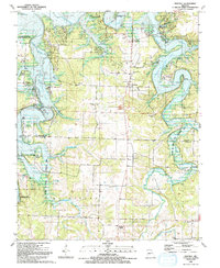
1991 Map of Sentinel
USGS Topo · Published 1991About this map
Pomme De Terre Lake dominates this landscape along the border of Hickory and Polk counties, its multi-fingered shoreline created by the inundation of the Lindley Creek valley and various tributaries. Small lakeside communities and recreational hubs such as Pittsburg, Nemo, and Adonis serve as anchors for the many boat ramps and public use areas that dot the shore, including the Wheatland Public Use Area and Lightfoot Public Use Area.
Find a feature on this map
42 named features on this map. Tap any name to fly to it.
Don’t see what you’re looking for? This feature index may not catch every label — zoom into the map to look around manually.
Map Details
Editions of this 1991 Sentinel Map
This is the sole edition of this map. No revisions or reprints were ever made.
Other maps of this area

1884 · Bolivar
USGS Topo · 1:125,000

1892 · Bolivar
USGS Topo · 1:125,000

1942 · Elkton
USGS Topo · 1:24,000

1949 · Elkton
USGS Topo · 1:24,000

1949 · Sentinel
USGS Topo · 1:24,000

1950 · Elkton
USGS Topo · 1:24,000

1950 · Sentinel
USGS Topo · 1:24,000

1950 · Buffalo NW
USGS Topo · 1:24,000

1950 · Polk
USGS Topo · 1:24,000

1950 · Urbana
USGS Topo · 1:24,000