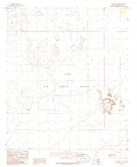
1986 Map of Sentinel SE
USGS Topo · Published 1986About this map
Luke Air Force Range dominates this portion of Maricopa County, reflecting the extensive military presence in the Arizona desert during the mid-1980s. The landscape is characterized by the broad, low expanse of Tartron Flat in the north and the distinct topographic rise of Cinder Mountain to the east. Isolated industrial and navigational markers like a Gravel Pit and a Control Tower punctuate the arid terrain, connected by a network of 4wd tracks rather than improved roads. This provisional survey captures the intersection of desert wilderness and military infrastructure, where high-relief volcanic features like Cinder Mountain serve as landmarks within the restricted airspace and bombing ranges.
Find a feature on this map
9 named features on this map. Tap any name to fly to it.
Don’t see what you’re looking for? This feature index may not catch every label — zoom into the map to look around manually.
Map Details
Editions of this 1986 Sentinel SE Map
This is the sole edition of this map. No revisions or reprints were ever made.
Other maps of this area

1949 · Sentinel
USGS Topo · 1:62,500

1950 · Sentinel
USGS Topo · 1:62,500

1950 · Theba
USGS Topo · 1:62,500

1951 · Theba
USGS Topo · 1:62,500

1953 · Ajo
USGS Topo · 1:250,000

1957 · Ajo
USGS Topo · 1:250,000

1958 · Ajo
USGS Topo · 1:250,000

1958 · Midway
USGS Topo · 1:62,500

1962 · Ajo
USGS Topo · 1:250,000

1963 · Ajo
USGS Topo · 1:250,000