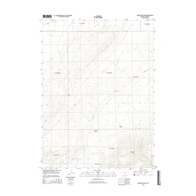
2015 Map of Separation Peak
USGS Topo · Published 2015About this map
Separation Peak dominates the high-elevation drainage divide of Carbon County, where the high desert meets the northern edges of the Haystack Mountains. This 2015 survey reveals a landscape defined by significant topographic relief, notably the prominent escarpment of the Red Rim and the sharp spine of Hogback Ridge. These features dictate the flow of ephemeral water sources like Separation Cr and Sugar Cr, which cut through deep recesses such as Ram Canyon and Scotty Canyon. Human presence is marked by the remote Twentymile Rd and the vital water management of Sixteenmile Reservoir. This map is particularly valuable for understanding the modern cattle-ranching and wildlife corridors in the Wyoming backcountry, capturing the area's essential geographic character before further infrastructure development.
Find a feature on this map
18 named features on this map. Tap any name to fly to it.
Don’t see what you’re looking for? This feature index may not catch every label — zoom into the map to look around manually.
Map Details
Editions of this 2015 Separation Peak Map
This is the sole edition of this map. No revisions or reprints were ever made.
Other maps of this area

1954 · Rawlins
USGS Topo · 1:250,000

1956 · Rawlins Peak
USGS Topo · 1:62,500

1956 · Bridger Pass
USGS Topo · 1:62,500

1958 · Rawlins
USGS Topo · 1:250,000

1962 · Rawlins
USGS Topo · 1:250,000

1966 · Riner
USGS Topo · 1:24,000

1966 · Fillmore Ranch
USGS Topo · 1:24,000
1966 · Antelope Spring
USGS Topo · 1:24,000

1967 · Rawlins
USGS Topo · 1:250,000
1983 · Coal Mine Ridge
USGS Topo · 1:24,000