
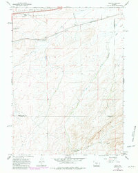
1966 Map of Riner
USGS Topo · Published 1969About this map
The Union Pacific railroad corridor dominates the northern landscape of this Sweetwater County study, where small rail-side settlements like Riner and Fillmore served the vital transportation artery across the Wyoming high desert. These outposts, marked by essential infrastructure such as a Water Tank at Riner, supported the steam and early diesel operations of the era. The terrain transitions from the rail-side flats toward the prominent Red Rim in the south, a significant geological break that defines the local drainage patterns. Water sources are scarce in this arid environment, making named features like Piker Spring and the ephemeral Separation Creek critical landmarks for surveying and local land use. Multiple pipelines crossing the northern sectors highlight the region's role in energy transit during the mid-1960s, cutting across the open range near Cherokee Hill.
Find a feature on this map
15 named features on this map. Tap any name to fly to it.
Don’t see what you’re looking for? This feature index may not catch every label — zoom into the map to look around manually.
Map Details
Editions of this 1966 Riner Map
2 editions found
Other maps of this area

1954 · Rawlins
USGS Topo · 1:250,000

1956 · Rawlins Peak
USGS Topo · 1:62,500

1956 · Bridger Pass
USGS Topo · 1:62,500

1958 · Rawlins
USGS Topo · 1:250,000

1962 · Rawlins
USGS Topo · 1:250,000

1966 · Jawbone Ranch
USGS Topo · 1:24,000

1966 · Creston Junction
USGS Topo · 1:24,000

1966 · Seaverson Reservoir
USGS Topo · 1:24,000

1966 · Fillmore Ranch
USGS Topo · 1:24,000
1966 · Antelope Spring
USGS Topo · 1:24,000