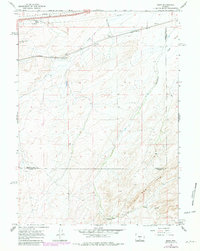
1966 Map of Riner
USGS Topo · Published 1981About this map
The Union Pacific railroad line cuts a straight path across this high desert landscape, serving as the primary corridor for movement and settlement during the mid-1960s. Small rail-side points like Riner and Fillmore punctuate the route, while Riner Road provides one of the few improved tracks through the sagebrush and scrub. To the north, the industrial footprint of the era is evident through a series of Pipelines and a specific Pipeline segment running parallel to the tracks.
Find a feature on this map
12 named features on this map. Tap any name to fly to it.
Don’t see what you’re looking for? This feature index may not catch every label — zoom into the map to look around manually.
Map Details
Editions of this 1966 Riner Map
2 editions found
Other maps of this area

1954 · Rawlins
USGS Topo · 1:250,000

1956 · Rawlins Peak
USGS Topo · 1:62,500

1956 · Bridger Pass
USGS Topo · 1:62,500

1958 · Rawlins
USGS Topo · 1:250,000

1962 · Rawlins
USGS Topo · 1:250,000

1966 · Jawbone Ranch
USGS Topo · 1:24,000

1966 · Creston Junction
USGS Topo · 1:24,000

1966 · Seaverson Reservoir
USGS Topo · 1:24,000

1966 · Riner
USGS Topo · 1:24,000

1966 · Fillmore Ranch
USGS Topo · 1:24,000