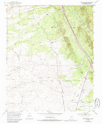
1952 Map of Seton Village
USGS Topo · Published 1985About this map
Large Spanish land grants define the geography of this New Mexico landscape south of Santa Fe, including the Sebastian De Vargas Grant and the Bishop John Lamy Grant. The terrain is characterized by a series of northwest-trending drainages such as Arroyo Hondo and Cañada de Minas that cut through the high desert floor. Central to the area's development is the Atchison Topeka and Santa Fe Railroad, which snakes through the valleys alongside traces of an Old Railroad Grade. This mid-century survey illustrates a transition from traditional ranching life at Rancho La Merced and Ninemile Ranch toward smaller settlements like Seton Village. The presence of a Landing Strip and the Gallina Camp suggest the varied land use of the era, from early aviation to seasonal operations in the foothills of the Cerros Negros.
Find a feature on this map
25 named features on this map. Tap any name to fly to it.
Don’t see what you’re looking for? This feature index may not catch every label — zoom into the map to look around manually.
Map Details
Editions of this 1952 Seton Village Map
5 editions found
Other maps of this area

1889 · Santa Fe
USGS Topo · 1:125,000

1892 · San Pedro
USGS Topo · 1:125,000

1892 · Santa Clara
USGS Topo · 1:125,000

1894 · Santa Fe
USGS Topo · 1:125,000

1894 · Lamy
USGS Topo · 1:125,000

1951 · Agua Fria
USGS Topo · 1:24,000

1951 · Turquoise Hill
USGS Topo · 1:24,000

1952 · Santa Fe
USGS Topo · 1:24,000

1952 · Turquoise Hill
USGS Topo · 1:24,000

1952 · Seton Village
USGS Topo · 1:24,000