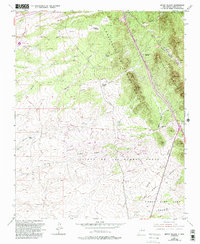
1952 Map of Seton Village
USGS Topo · Published 1993About this map
Seton Village lies at the heart of this landscape south of Santa Fe, situated among the arroyos and canyons that define the foothills of the Sierra de los Valles. The map highlights complex land tenure patterns in the region, particularly the extensive Pueblo de Cañon de los Alamos Grant and the Bishop John Lamy Grant, reflecting the area's deep Spanish colonial and ecclesiastical history. While the northern portion shows established estates like Rancho La Merced and El Rancho Montoso, the southern section features the newer residential layout of El Dorado with its looping street network, including Veraño Loop and Peraño Loop. The Atchison Topeka and Santa Fe Railroad cuts through the eastern terrain near Cañon Ancha, serving as a vital transportation corridor through the high desert. Modern educational expansion is evidenced by the Santa Fe Community College near the Arroyo Hondo.
Find a feature on this map
35 named features on this map. Tap any name to fly to it.
Don’t see what you’re looking for? This feature index may not catch every label — zoom into the map to look around manually.
Map Details
Editions of this 1952 Seton Village Map
5 editions found
Other maps of this area

1889 · Santa Fe
USGS Topo · 1:125,000

1892 · San Pedro
USGS Topo · 1:125,000

1892 · Santa Clara
USGS Topo · 1:125,000

1894 · Santa Fe
USGS Topo · 1:125,000

1894 · Lamy
USGS Topo · 1:125,000

1951 · Agua Fria
USGS Topo · 1:24,000

1951 · Turquoise Hill
USGS Topo · 1:24,000

1952 · Santa Fe
USGS Topo · 1:24,000

1952 · Turquoise Hill
USGS Topo · 1:24,000

1952 · Seton Village
USGS Topo · 1:24,000