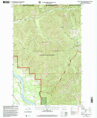
1997 Map of Seven Point Mountain
USGS Topo · Published 2000About this map
Noxon Reservoir and the Clark Fork define the southwestern corner of this mountain landscape, which shows the intersection of the Kaniksu National Forest and Lolo National Forest in late-twentieth-century Sanders County. The terrain is marked by high summits like Seven Point Mountain and Cataract Peak, with many deep drainages such as Miners Gulch, Cameron Gulch, and Grimes Gulch feeding into the larger river systems. Small settlements like Childs and Pinecone sit near the water's edge, while the rugged interior is accessible only by established routes like the Water Hill Trail 345 and the Grouse Mountain Trail. This survey captures a moment when the Cabinet Falls Ranger District managed these vast tracts of timber and high-altitude basins, including isolated water bodies like Marmot Lakes and Bear Lake.
Find a feature on this map
42 named features on this map. Tap any name to fly to it.
Don’t see what you’re looking for? This feature index may not catch every label — zoom into the map to look around manually.
Map Details
Editions of this 1997 Seven Point Mountain Map
This is the sole edition of this map. No revisions or reprints were ever made.
Other maps of this area

1932 · Trout Creek
USGS Topo · 1:125,000

1935 · Trout Creek
USGS Topo · 1:125,000

1936 · Trout Creek
USGS Topo · 1:125,000

1937 · Thompson Falls
USGS Topo · 1:125,000

1937 · Thompson Falls
USGS Topo · 1:62,500

1956 · Cooper Gulch
USGS Topo · 1:62,500

1956 · Wallace
USGS Topo · 1:250,000

1957 · Thompson Falls
USGS Topo · 1:62,500

1960 · Wallace
USGS Topo · 1:250,000

1966 · Vermilion Peak
USGS Topo · 1:24,000