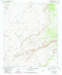
1979 Map of Seven Springs
USGS Topo · Published 1984About this map
Arid drainage patterns and livestock infrastructure define this portion of Apache County during the late 1970s and early 1980s. The landscape is dominated by the seasonal paths of Milky Wash and Beaver Dam Wash, which cut through the high desert terrain. The distribution of water sources, often bearing the names of local figures or landmarks, reveals the ranching history of the area. Notable sites include Pat Hughes Tank, Reuell Jarvis Tank, and Corral Pablo Tank, which served as vital collection points in an environment where water was the primary driver of land use. To the southeast, the Seven Springs Wash leads toward the Seven Springs Corral, a central fixture for managing cattle across these townships. A network of Jeep Trails provides the only access through the backcountry, following the contours of the washes and ridges between various named tanks like Rim Tank and Antelope Tank.
Find a feature on this map
16 named features on this map. Tap any name to fly to it.
Don’t see what you’re looking for? This feature index may not catch every label — zoom into the map to look around manually.
Map Details
Editions of this 1979 Seven Springs Map
2 editions found
Other maps of this area

1886 · St Johns
USGS Topo · 1:250,000

1892 · St Johns
USGS Topo · 1:250,000

1954 · Saint Johns
USGS Topo · 1:250,000

1955 · Adamana 1 SW
USGS Topo · 1:24,000

1955 · Adamana 4 NE
USGS Topo · 1:24,000

1955 · Adamana 4 NW
USGS Topo · 1:24,000

1955 · Wolford Springs 3 NW
USGS Topo · 1:24,000

1955 · Hunt
USGS Topo · 1:62,500

1956 · Adamana 1 NW
USGS Topo · 1:24,000

1957 · Saint Johns
USGS Topo · 1:250,000