
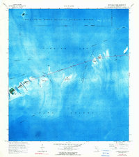
1972 Map of Sevenmile Bridge
USGS Topo · Published 1973About this map
Sevenmile Bridge serves as the structural spine of this 1970s orthophotomap, spanning the transition between Florida Bay and Hawk Channel. This specific survey captures the Florida Keys during a period of established transportation infrastructure, highlighting the narrow landmasses of Knight Key, Pigeon Key, and Little Duck Key as they are linked by the highway. To the north, the protected waters of the Great White Heron National Wildlife Refuge dominate the landscape, characterized by shallow banks like Bethel Bank and isolated outposts such as Coconaut Key. The orthophoto format provides unique insight into the underwater topography and shoal patterns surrounding the keys, including the detailed routes of the Money Key Channel and Missouri Channel. This view is particularly valuable for understanding the maritime geography of the Middle Keys before significant modern expansion altered the coastal fringes.
Find a feature on this map
23 named features on this map. Tap any name to fly to it.
Don’t see what you’re looking for? This feature index may not catch every label — zoom into the map to look around manually.
Map Details
Editions of this 1972 Sevenmile Bridge Map
2 editions found
Other maps of this area

1971 · Marathon
USGS Topo · 1:24,000

1972 · Marathon
USGS Topo · 1:24,000

1972 · Bamboo Key
USGS Topo · 1:24,000

1972 · Big Pine Key
USGS Topo · 1:24,000

1972 · East Bahia Honda Key
USGS Topo · 1:24,000

1972 · Horseshoe Keys
USGS Topo · 1:24,000

1983 · Key West
USGS Topo · 1:100,000

1989 · Key West
USGS Topo · 1:250,000
2012 · Horseshoe Keys
USGS Topo · 1:24,000
2012 · East Bahia Honda Key
USGS Topo · 1:24,000