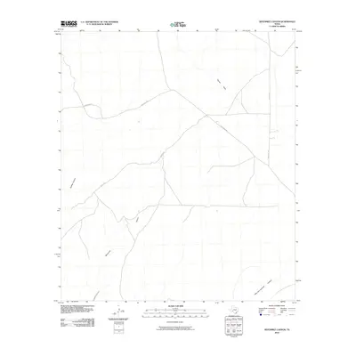
2010 Map of Sevenmile Canyon
USGS Topo · Published 2010About this map
Sevenmile Canyon and the surrounding drainage network of Val Verde County define this arid stretch of West Texas as it appeared in 2010. The landscape is carved by deep watercourses such as Osman Draw and Outlaw Canyon, which highlight the region's complex natural irrigation and erosion patterns. In the southeastern corner, the curiously named Mile and one-Half Canyon joins the network. Human presence is marked primarily by ranch-to-market style roads, including Chriesman Rd, Gurley Rd, and Pumpville Rd, which traverse the wide plateaus between the canyons. This survey documents the sparse, purposeful infrastructure typical of the high desert, where limited roads serve isolated ranching interests and provide access through the significant topographical relief of the canyon system.
Find a feature on this map
7 named features on this map. Tap any name to fly to it.
Don’t see what you’re looking for? This feature index may not catch every label — zoom into the map to look around manually.
Map Details
Editions of this 2010 Sevenmile Canyon Map
This is the sole edition of this map. No revisions or reprints were ever made.
Other maps of this area

1943 · Malvado
USGS Topo · 1:62,500

1943 · Langtry
USGS Topo · 1:62,500

1944 · Malvado
USGS Topo · 1:62,500

1954 · Sonora
USGS Topo · 1:250,000

1958 · Sonora
USGS Topo · 1:250,000

1958 · Del Rio
USGS Topo · 1:250,000

1964 · Del Rio
USGS Topo · 1:250,000
1973 · Hackberry Crossing
USGS Topo · 1:24,000
1979 · Cook Creek North
USGS Topo · 1:24,000
1979 · Lozier Canyon North
USGS Topo · 1:24,000