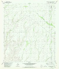
1980 Map of Sevenmile Canyon
USGS Topo · Published 1980About this map
Sevenmile Canyon and its complex network of tributaries define this high-desert landscape along the border of Terrell and Val Verde counties. The geography is dominated by deep drainage systems like Osman Draw and Outlaw Canyon, which cut through the arid terrain. Human presence is sparse, indicated primarily by isolated water infrastructure essential for ranching and survival in the Trans-Pecos region. Named points such as Hoddy, several Well sites, and a Tank highlight the critical role of water management in this semi-arid environment. In the southern reaches of the sheet, the terrain drops toward Mile and One-Half Canyon, illustrating the relentless erosive forces that have shaped this portion of the Edwards Plateau. The lack of major roads or settlements reflects a remote ranching economy focused on large-scale land holdings and sustainable water access.
Find a feature on this map
8 named features on this map. Tap any name to fly to it.
Don’t see what you’re looking for? This feature index may not catch every label — zoom into the map to look around manually.
Map Details
Editions of this 1980 Sevenmile Canyon Map
This is the sole edition of this map. No revisions or reprints were ever made.
Other maps of this area

1943 · Malvado
USGS Topo · 1:62,500

1943 · Langtry
USGS Topo · 1:62,500

1944 · Malvado
USGS Topo · 1:62,500

1954 · Sonora
USGS Topo · 1:250,000

1958 · Sonora
USGS Topo · 1:250,000

1958 · Del Rio
USGS Topo · 1:250,000

1964 · Del Rio
USGS Topo · 1:250,000
1973 · Hackberry Crossing
USGS Topo · 1:24,000
1979 · Cook Creek North
USGS Topo · 1:24,000
1979 · Lozier Canyon North
USGS Topo · 1:24,000