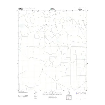
2012 Map of Sevenmile Corner SE
USGS Topo · Published 2012About this map
Benedum Oil Field defines the industrial character of this Reagan County landscape, reflecting the region's deep ties to petroleum extraction. The infrastructure for this industry is supported by a network of rural roads, including Ranch Road 1555 and Ranch Road 2694, which provide access across the arid terrain. The settlement of Benedum Camp serves as a focal point for local habitation, likely established to house the workforce required for the surrounding operations. Aside from these industrial markers, the landscape is organized by a geometric grid of county roads such as Co Rd-250 and Co Rd-230. This survey illustrates the specialized land use typical of the Permian Basin, where residential pockets and energy production coexist within a vast expanse of open country defined by long-distance thoroughfares like Elliott Rd.
Find a feature on this map
12 named features on this map. Tap any name to fly to it.
Don’t see what you’re looking for? This feature index may not catch every label — zoom into the map to look around manually.
Map Details
Editions of this 2012 Sevenmile Corner SE Map
This is the sole edition of this map. No revisions or reprints were ever made.
Other maps of this area

1928 · Rankin
USGS Topo · 1:125,000

1954 · San Angelo
USGS Topo · 1:250,000

1958 · San Angelo
USGS Topo · 1:250,000

1965 · San Angelo
USGS Topo · 1:250,000

1970 · Sevenmile Corner NE
USGS Topo · 1:24,000

1970 · Stiles NW
USGS Topo · 1:24,000

1970 · Lindsey Ranch
USGS Topo · 1:24,000

1970 · Sevenmile Corner SE
USGS Topo · 1:24,000

1970 · Sevenmile Corner
USGS Topo · 1:24,000
1970 · Rankin NE
USGS Topo · 1:24,000