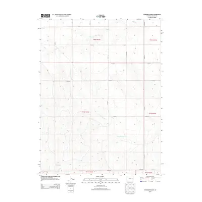
2013 Map of Sevenmile Ranch
USGS Topo · Published 2013About this map
Sevenmile Ranch sits at the southwestern edge of this 2013 topographic survey, marking a distinct point of human activity in the high plains of eastern Lincoln County. The landscape is defined by the drainage patterns of the S Fork Republican River, which winds across the central and southern sections of the quadrangle. This intermittent waterway, along with its tributaries Buffalo Cr to the north and Sevenmile Cr and W Sevenmile Cr to the south, illustrates the subtle but critical hydrography of the region. The map reveals a strictly organized grid of county roads, such as CO Road 3E and CO Road 43, which delineate section lines and facilitate movement across the agricultural and ranching terrain. These roads and watercourses provide essential context for understanding land use and property boundaries within the historic townships of this Colorado corridor.
Find a feature on this map
23 named features on this map. Tap any name to fly to it.
Don’t see what you’re looking for? This feature index may not catch every label — zoom into the map to look around manually.
Map Details
Editions of this 2013 Sevenmile Ranch Map
This is the sole edition of this map. No revisions or reprints were ever made.
Other maps of this area

1954 · Limon
USGS Topo · 1:250,000

1957 · Limon
USGS Topo · 1:250,000

1958 · Limon
USGS Topo · 1:250,000

1978 · Clifford
USGS Topo · 1:24,000

1978 · Hugo 4 NW
USGS Topo · 1:24,000

1979 · Sevenmile Ranch
USGS Topo · 1:24,000
1979 · Clifford
USGS Topo · 1:24,000

1979 · Arriba
USGS Topo · 1:24,000

1979 · Flagler SW
USGS Topo · 1:24,000

1979 · Genoa East
USGS Topo · 1:24,000