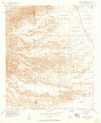
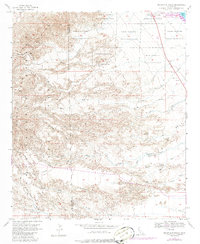
1956 Map of Seventeen Palms
USGS Topo · Published 1958About this map
The Torres Martinez Indian Reservation occupies much of this arid landscape, which is defined by a complex network of ephemeral watercourses and desert landmarks. Surveyed in the mid-1950s, the area shows the rugged character of the Santa Rosa Mountains and the lower reaches near the Salton Sea. Vital water sources for travelers and residents are marked at Seventeen Palms, Four Palms Spring, and Tippy Spring, highlighting the critical importance of these desert oases.
Find a feature on this map
36 named features on this map. Tap any name to fly to it.
Don’t see what you’re looking for? This feature index may not catch every label — zoom into the map to look around manually.
Map Details
Editions of this 1956 Seventeen Palms Map
5 editions found
Other maps of this area

1904 · Indio
USGS Topo · 1:125,000

1931 · Vallecito
USGS Topo · 1:125,000

1940 · Kane Spring
USGS Topo · 1:62,500

1940 · Durmid
USGS Topo · 1:62,500

1942 · Barrel Spring
USGS Topo · 1:62,500

1942 · Agua Dulce
USGS Topo · 1:62,500

1943 · Vallecito
USGS Topo · 1:125,000

1944 · Agua Dulce
USGS Topo · 1:62,500

1944 · Durmid
USGS Topo · 1:62,500

1944 · Kane Spring
USGS Topo · 1:62,500