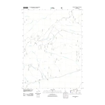
2011 Map of Severe Spring
USGS Topo · Published 2011About this map
Severe Spring and the surrounding high-country water sources anchor this remote corner of Cassia County, providing a glimpse into the vital hydrology of the Idaho landscape in the early 21st century. The map illustrates a complex network of seasonal drainages and permanent springs, such as North Water Spring and Big Pipe Spring, which have historically supported livestock and wildlife. These water points are often named for early settlers or distinctive local flora, as seen with Cedar Birch Spring and Dummer Spring.
Find a feature on this map
33 named features on this map. Tap any name to fly to it.
Don’t see what you’re looking for? This feature index may not catch every label — zoom into the map to look around manually.
Map Details
Editions of this 2011 Severe Spring Map
This is the sole edition of this map. No revisions or reprints were ever made.
Other maps of this area

1954 · Pocatello
USGS Topo · 1:250,000

1955 · Twin Falls
USGS Topo · 1:250,000

1958 · Twin Falls
USGS Topo · 1:250,000

1958 · Pocatello
USGS Topo · 1:250,000

1965 · Rams Horn Ridge
USGS Topo · 1:24,000

1965 · Buckhorn Canyon
USGS Topo · 1:24,000
1968 · Blue Hill
USGS Topo · 1:24,000
1968 · Oakley
USGS Topo · 1:24,000
1968 · Marion
USGS Topo · 1:24,000

1977 · Mahogany Butte
USGS Topo · 1:24,000