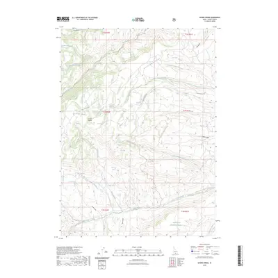
2023 Map of Severe Spring
USGS Topo · Published 2023About this map
Sawtooth National Forest dominates this high-elevation terrain in Cassia County, where the southern reaches of the Cottonwood Ridge meet the northern drainages of Trapper Creek. The landscape is defined by a dense network of seasonal and perennial springs, such as Severe Spring and Buckbrush Spring, which historically supported the high-altitude ranching and timber activities in the area. Evidence of early mountain industry is found along Sawmill Creek, while Durfee Meadow provides a notable clearing within the timbered slopes. Extensive forest service trails, including the Big Cottonwood Trl and Cave Canyon Trl, crisscross the ridges and canyons, reflecting the long-standing use of these public lands for transit and resource management. The map also captures Indigenous presence through traditionally named routes such as Nammi'i Naakwaite and Pasi'i Naakwaite, which traverse the southern draws near Dammer Spring.
Find a feature on this map
49 named features on this map. Tap any name to fly to it.
Don’t see what you’re looking for? This feature index may not catch every label — zoom into the map to look around manually.
Map Details
Editions of this 2023 Severe Spring Map
This is the sole edition of this map. No revisions or reprints were ever made.
Other maps of this area

1954 · Pocatello
USGS Topo · 1:250,000

1955 · Twin Falls
USGS Topo · 1:250,000

1958 · Twin Falls
USGS Topo · 1:250,000

1958 · Pocatello
USGS Topo · 1:250,000

1965 · Rams Horn Ridge
USGS Topo · 1:24,000

1965 · Buckhorn Canyon
USGS Topo · 1:24,000
1968 · Blue Hill
USGS Topo · 1:24,000
1968 · Oakley
USGS Topo · 1:24,000
1968 · Marion
USGS Topo · 1:24,000

1977 · Mahogany Butte
USGS Topo · 1:24,000