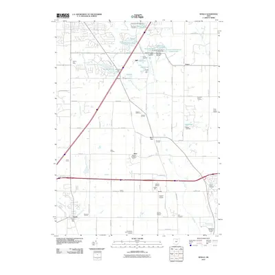
2010 Map of Seville
USGS Topo · Published 2010About this map
Seville and the surrounding townships in Medina County are defined by a network of rural settlements and family-named landmarks connected by the Styx River and Chippewa Creek. Small community centers like River Styx, Poe, and Acme anchor the agricultural landscape, which is dotted with numerous private lakes and reservoirs such as Jeans Lake and Sunnyslope Lake. The prevalence of spiritual and commemorative sites is notable, ranging from the Old Mennonite Cemetery and Jerusalem Lutheran Cemetery to the extensive Ohio Western Reserve National Cemetery. Transportation infrastructure is a mix of old and new, where local routes like Mennonite Rd intersect with aviation facilities including the Weltzien Skypark and Wadsworth Municipal Airport. Local agricultural roots remain visible through features like Geigs Orchard, even as modern residential developments emerge around Montville Lakes.
Find a feature on this map
83 named features on this map. Tap any name to fly to it.
Don’t see what you’re looking for? This feature index may not catch every label — zoom into the map to look around manually.
Map Details
Editions of this 2010 Seville Map
This is the sole edition of this map. No revisions or reprints were ever made.
Other maps of this area

1901 · Massillon
USGS Topo · 1:62,500

1901 · Wooster
USGS Topo · 1:62,500

1903 · Massillon
USGS Topo · 1:62,500

1903 · Wooster
USGS Topo · 1:62,500

1903 · Akron
USGS Topo · 1:62,500

1904 · Medina
USGS Topo · 1:62,500

1905 · Akron
USGS Topo · 1:62,500

1906 · Medina
USGS Topo · 1:62,500

1950 · Cleveland
USGS Topo · 1:250,000

1951 · Canton
USGS Topo · 1:250,000