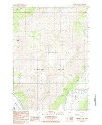
1984 Map of Seward D-6 NE
USGS Topo · Published 1984About this map
Chugach National Forest dominates this Alaskan landscape during the mid-1970s and early 1980s, revealing a terrain defined by massive glaciation and dramatic elevation changes. The map documents the northern reaches of Turnagain Arm where the salt water meets the mountain drainage systems of Peterson Creek and Kern Creek. Higher elevations are marked by the prominent peak of Mount Alyeska, a landmark that serves as a focal point for the region's geography. The drainage patterns are clearly delineated, showing how the Twentymile River and smaller tributaries like Winner Creek carve through the high country. From the coastal mudflats to the alpine rise of Blueberry Hill, this provisional survey records the natural boundaries and physical features of the Kenai Peninsula hinterland before later development and environmental shifts.
Find a feature on this map
9 named features on this map. Tap any name to fly to it.
Don’t see what you’re looking for? This feature index may not catch every label — zoom into the map to look around manually.
Map Details
Editions of this 1984 Seward D-6 NE Map
This is the sole edition of this map. No revisions or reprints were ever made.
Other maps of this area

1951 · Seward
USGS Topo · 1:250,000

1951 · Anchorage
USGS Topo · 1:250,000

1951 · Seward D-5
USGS Topo · 1:63,360

1951 · Seward D-6
USGS Topo · 1:63,360

1952 · Seward D-5
USGS Topo · 1:63,360

1952 · Seward D-6
USGS Topo · 1:63,360

1953 · Seward
USGS Topo · 1:250,000

1959 · Seward
USGS Topo · 1:250,000

1960 · Anchorage A-6
USGS Topo · 1:63,360

1960 · Anchorage A-5
USGS Topo · 1:63,360