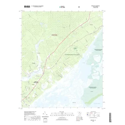
2020 Map of Sewee Bay
USGS Topo · Published 2020About this map
Sewee Bay and its complex network of tidal creeks and marshlands define this coastal stretch of South Carolina. The landscape is dominated by the sprawling conservation lands of the Cape Romain National Wildlife Refuge and the southern reaches of the Francis Marion National Forest. Inland from the Intracoastal Waterway, small rural settlements such as Awendaw, Woodville, and Ten Mile line the historic road corridors. Genealogists will find the Wappetaw Cem situated near the intersection of Seewee Rd, a landmark for local family history. The map detail extends to the riverine environments of the Wando River and Guerin Cr, while offshore features like Bull Island and Capers Island protect the mainland from the Atlantic Ocean. The presence of numerous named secondary roads, including Gadsdenville Rd and Hutchinson Rd, illustrates the residential patterns of the Lowcountry at this time.
Find a feature on this map
61 named features on this map. Tap any name to fly to it.
Don’t see what you’re looking for? This feature index may not catch every label — zoom into the map to look around manually.
Map Details
Editions of this 2020 Sewee Bay Map
This is the sole edition of this map. No revisions or reprints were ever made.
Other maps of this area

1919 · Capers Island
USGS Topo · 1:21,120

1919 · Wando
USGS Topo · 1:21,120

1919 · Cordesville
USGS Topo · 1:48,000

1919 · Fort Moultrie
USGS Topo · 1:21,120

1919 · Bulls Island
USGS Topo · 1:21,120

1919 · Sewee Bay
USGS Topo · 1:21,120

1943 · Capers Island
USGS Topo · 1:24,000

1943 · Fort Moultrie
USGS Topo · 1:24,000

1943 · Wando
USGS Topo · 1:24,000

1943 · Sewee Bay
USGS Topo · 1:24,000