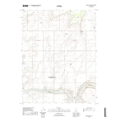
2020 Map of Sewing Machine
USGS Topo · Published 2020About this map
Glen Canyon National Recreation Area dominates this landscape where the Colorado River meets the upper reaches of Lake Powell. This survey documents the canyonlands at a time when the water level of the reservoir defines the character of Narrow Canyon and the winding Mille Crag Bend. The confluence of the Dirty Devil River and the main stem of the Colorado is a primary focal point, marked by the proximity of Hite Crossing and the Hite Airport. High desert plateaus like Dry Mesa and Andy Miller Flats overlook the deeply incised drainage systems of Cataract Canyon and Cove Canyon. Distinctive geological formations, including The Sewing Machine, Grainery Rock, and the Red Benches, provide significant landmarks across the San Juan and Garfield County line. For those interested in the hydrology and geography of the Colorado Plateau, this map preserves the mid-20th-century footprint of transportation and recreation infrastructure within this wilderness.
Find a feature on this map
24 named features on this map. Tap any name to fly to it.
Don’t see what you’re looking for? This feature index may not catch every label — zoom into the map to look around manually.
Map Details
Editions of this 2020 Sewing Machine Map
This is the sole edition of this map. No revisions or reprints were ever made.
Other maps of this area

1885 · San Rafael
USGS Topo · 1:250,000

1886 · Henry Mountains
USGS Topo · 1:250,000

1892 · Henry Mountains
USGS Topo · 1:250,000

1952 · Mouth of Dark Canyon
USGS Topo · 1:62,500

1952 · Orange Cliffs 3 SW
USGS Topo · 1:24,000

1952 · Hite
USGS Topo · 1:62,500

1953 · Orange Cliffs 3 SE
USGS Topo · 1:24,000

1953 · Orange Cliffs 4 SW
USGS Topo · 1:24,000

1953 · Fiddler Butte
USGS Topo · 1:62,500

1953 · Orange Cliffs
USGS Topo · 1:62,500