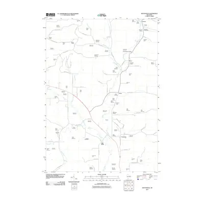
2010 Map of Sextonville
USGS Topo · Published 2010About this map
Ithaca and Neptune anchor this 2010 portrait of Richland County’s dairy heartland, where the Pine River and Willow Creek carve deep valleys through the driftless landscape. The map reveals an intensive agricultural pattern, marked by numerous family-named operations such as the West Willow Stock and Dairy Farm and Sun Valley Holstein Farm. These agricultural legacies are deeply rooted, as evidenced by several community burial grounds including Sextonville Cemetery and Ash Creek Cemetery. Unique geological and topographic features like Elephant Trunk Rock, Twin Bluffs, and Hulster Ridge define the local horizon. The presence of the Richland Airport and the Calhoun G7989 Dam near the center of the sheet highlights how modern infrastructure and water management have integrated with the traditional valley farming communities of Aubrey and its surrounding hollows.
Find a feature on this map
106 named features on this map. Tap any name to fly to it.
Don’t see what you’re looking for? This feature index may not catch every label — zoom into the map to look around manually.
Map Details
Editions of this 2010 Sextonville Map
This is the sole edition of this map. No revisions or reprints were ever made.
Other maps of this area

1905 · Richland Center
USGS Topo · 1:125,000

1958 · La Crosse
USGS Topo · 1:250,000

1960 · Richland Center
USGS Topo · 1:62,500

1960 · Plain
USGS Topo · 1:62,500

1960 · Muscoda
USGS Topo · 1:62,500

1960 · Spring Green
USGS Topo · 1:62,500

1961 · La Crosse
USGS Topo · 1:250,000

1965 · La Crosse
USGS Topo · 1:250,000

1976 · La Crosse
USGS Topo · 1:250,000
1983 · Lime Ridge
USGS Topo · 1:24,000