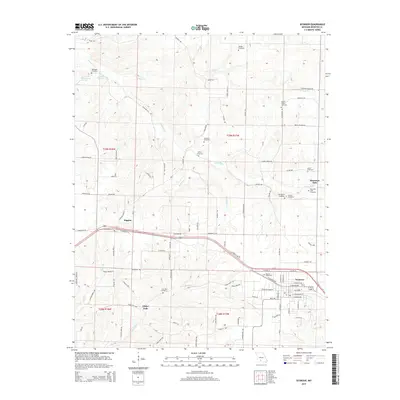
2015 Map of Seymour
USGS Topo · Published 2015About this map
Seymour and Diggins anchor this high-elevation Ozark landscape, where the headwaters of the James River and Little Finley Cr divide the terrain. This 2015 survey reveals a dense concentration of lineage-rich sites, reflecting the long-standing agricultural and family traditions of Webster County. Scattered burial grounds such as Childress Cemetery, Gentry Cemetery, and George Cemetery are tucked away along rural routes like Teagues Rd and Gentry Rd. Of particular interest to local historians is the Civil War Cemetery located south of the main corridor, along with the Masonic Cemetery in the eastern part of the quadrangle. The settlement pattern follows the established lines of the highway and older rural networks like Amish Loop, showing a persistent mix of small-town centers and dispersed family homesteads near landmarks like Finley Falls.
Find a feature on this map
98 named features on this map. Tap any name to fly to it.
Don’t see what you’re looking for? This feature index may not catch every label — zoom into the map to look around manually.
Map Details
Editions of this 2015 Seymour Map
This is the sole edition of this map. No revisions or reprints were ever made.
Other maps of this area

1939 · Fordland
USGS Topo · 1:62,500

1942 · Fordland
USGS Topo · 1:62,500

1946 · Niangua
USGS Topo · 1:62,500

1948 · Niangua
USGS Topo · 1:62,500

1951 · Mansfield NW
USGS Topo · 1:24,000
1951 · Cedar Gap
USGS Topo · 1:24,000

1954 · Springfield
USGS Topo · 1:250,000

1956 · Duncan
USGS Topo · 1:24,000

1958 · Springfield
USGS Topo · 1:250,000

1959 · Springfield
USGS Topo · 1:250,000