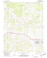
1982 Map of Seymour
USGS Topo · Published 1983About this map
The town of Seymour serves as the primary hub of this Webster County landscape, situated at a major bend in the Burlington Northern railroad. The surrounding terrain of High Prairie and Hazelwood is marked by a dense concentration of family and community landmarks, reflecting a deep-rooted history. Of particular note for genealogists is the Civil War Cem located near Finley Creek, alongside numerous other burial grounds like Masonic Cems and the Mountain Dale Cem. Industrial and social history is visible through the Porter Mine, the Bright Prairie Sch, and the Drive-in Theater on the eastern edge of Seymour. The headwaters of the James River and the small cascade at Finley Falls define the local drainage, while smaller communities like Diggins and Ford appear as vital stops along the rail line.
Find a feature on this map
49 named features on this map. Tap any name to fly to it.
Don’t see what you’re looking for? This feature index may not catch every label — zoom into the map to look around manually.
Map Details
Editions of this 1982 Seymour Map
This is the sole edition of this map. No revisions or reprints were ever made.
Other maps of this area

1939 · Fordland
USGS Topo · 1:62,500

1942 · Fordland
USGS Topo · 1:62,500

1946 · Niangua
USGS Topo · 1:62,500

1948 · Niangua
USGS Topo · 1:62,500

1951 · Mansfield NW
USGS Topo · 1:24,000
1951 · Cedar Gap
USGS Topo · 1:24,000

1954 · Springfield
USGS Topo · 1:250,000

1956 · Duncan
USGS Topo · 1:24,000

1958 · Springfield
USGS Topo · 1:250,000

1959 · Springfield
USGS Topo · 1:250,000