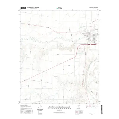
2016 Map of Seymour West
USGS Topo · Published 2016About this map
Seymour serves as the focal point of this western Baylor County landscape, positioned where the Brazos River winds through the northern portion of the quadrangle. The terrain is defined by a dense network of seasonal drainages and creek beds, including Cache Cr, Polecat Cr, and Seymour Cr, which carve through the plains south of the main river valley. This 2016 survey illustrates the modern rural infrastructure of the region, anchored by a systematic grid of county roads such as Co RD 404 and Co RD 415 that serve the outlying ranching and agricultural lands. Genealogists and local historians can locate the Cache Creek Cem nestled in the southern reaches of the map, while the Seymour Country Club Lake marks a distinct recreational landmark just south of the city limits.
Find a feature on this map
87 named features on this map. Tap any name to fly to it.
Don’t see what you’re looking for? This feature index may not catch every label — zoom into the map to look around manually.
Map Details
Editions of this 2016 Seymour West Map
This is the sole edition of this map. No revisions or reprints were ever made.
Other maps of this area

1954 · Wichita Falls
USGS Topo · 1:250,000

1958 · Wichita Falls
USGS Topo · 1:250,000

1962 · Antelope Creek NE
USGS Topo · 1:24,000

1962 · Antelope Creek NW
USGS Topo · 1:24,000

1966 · Seymour West
USGS Topo · 1:24,000

1966 · Rock Canyon
USGS Topo · 1:24,000

1966 · Soap Creek
USGS Topo · 1:24,000

1966 · Southeast Lake Kemp
USGS Topo · 1:24,000

1966 · Bomarton
USGS Topo · 1:24,000

1966 · Southwest Lake Kemp
USGS Topo · 1:24,000