
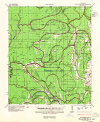
1935 Map of Shackleford Lake
USGS Topo · Published 1942About this map
The Tensas River meanders through a landscape defined by industrial logging and alluvial agriculture during the mid-1930s. The region is heavily marked by the operations of the Chicago and Lumber Company Railroad and the Fisher Hurd Lumber Company Railroad, which penetrate the dense bayous and sloughs. Settlement patterns reflect the era's plantation economy and labor structure, visible in places like Marydale Plantation, New Quarters, and Saranac. Along the riverbanks, specialized infrastructure like the Ferry Newlight Log near Newlight and various log landings such as Bengal Log and Remolina Log highlight the primary method of moving timber. Evidence of much earlier inhabitants remains on the landscape at Indian Mounds near Shackleford Lake, while local spiritual life is anchored by rural landmarks like Stonewall Ch and Magnolia Ch.
Find a feature on this map
92 named features on this map. Tap any name to fly to it.
Don’t see what you’re looking for? This feature index may not catch every label — zoom into the map to look around manually.
Map Details
Editions of this 1935 Shackleford Lake Map
2 editions found
Other maps of this area

1909 · Delta Bridge
USGS Topo · 1:24,000

1909 · Lake Bruen
USGS Topo · 1:24,000

1935 · Winnsboro
USGS Topo · 1:62,500

1935 · Baskinton
USGS Topo · 1:62,500

1935 · Waverly
USGS Topo · 1:62,500

1939 · Talla Bena
USGS Topo · 1:62,500

1939 · Lorman
USGS Topo · 1:62,500

1939 · Locust Ridge
USGS Topo · 1:62,500

1941 · Sicily Island
USGS Topo · 1:62,500

1953 · Natchez
USGS Topo · 1:250,000