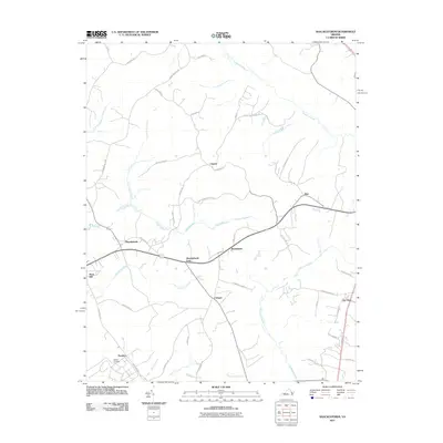
2011 Map of Shacklefords
USGS Topo · Published 2011About this map
Dragon Swamp and the Poropotank River define the intricate waterways of this Virginia coastal plain landscape. The transition from tidal river to expansive swamp land influenced the placement of early rural hubs like Shacklefords and Beulahland. Small crossroads and communities are scattered throughout the interior, often centered around family-named landmarks such as Hockley Cemetery and the settlement of Hockley. The road network, including routes like Stratton Major Rd and Royal Oak School Rd, suggests a long history of agricultural activity and local school districts. Water features such as Glebe Swamp, Goalders Creek, and Bakers Creek further carve through the terrain, illustrating the dense drainage patterns that have shaped the development and geography of this region over generations.
Find a feature on this map
48 named features on this map. Tap any name to fly to it.
Don’t see what you’re looking for? This feature index may not catch every label — zoom into the map to look around manually.
Map Details
Editions of this 2011 Shacklefords Map
This is the sole edition of this map. No revisions or reprints were ever made.
Other maps of this area

1906 · Williamsburg
USGS Topo · 1:62,500

1917 · Urbanna
USGS Topo · 1:62,500

1917 · Toano
USGS Topo · 1:62,500

1918 · Toano
USGS Topo · 1:62,500

1919 · New Kent
USGS Topo · 1:62,500

1943 · Richmond
USGS Topo · 1:250,000
1946 · Urbanna
USGS Topo · 1:24,000
1949 · Truhart
USGS Topo · 1:24,000
1949 · Saluda
USGS Topo · 1:24,000

1949 · Shacklefords
USGS Topo · 1:24,000