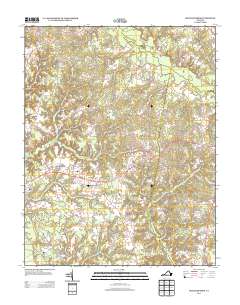
2013 Map of Shacklefords
USGS Topo · Published 2013About this map
Dragon Swamp and Glebe Swamp define the low-lying drainage patterns of this coastal Virginia landscape, where small crossroads communities anchor the higher ground between tidal tributaries. In the early 21st century, the area remains dominated by a network of rural routes, including the Lewis B Puller Memorial HWY which serves as a central east-west corridor through Shacklefords Fork and Beulahland.
Find a feature on this map
26 named features on this map. Tap any name to fly to it.
Don’t see what you’re looking for? This feature index may not catch every label — zoom into the map to look around manually.
Map Details
Editions of this 2013 Shacklefords Map
This is the sole edition of this map. No revisions or reprints were ever made.
Other maps of this area

1906 · Williamsburg
USGS Topo · 1:62,500

1917 · Urbanna
USGS Topo · 1:62,500

1917 · Toano
USGS Topo · 1:62,500

1918 · Toano
USGS Topo · 1:62,500

1919 · New Kent
USGS Topo · 1:62,500

1943 · Richmond
USGS Topo · 1:250,000
1946 · Urbanna
USGS Topo · 1:24,000
1949 · Truhart
USGS Topo · 1:24,000
1949 · Saluda
USGS Topo · 1:24,000

1949 · Shacklefords
USGS Topo · 1:24,000