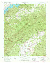
1960 Map of Shady Valley
USGS Topo · Published 1971About this map
Shady Valley occupies a high-altitude basin between the Iron Mountains and the Kettlefoot range, presenting a distinct landscape of mountain farming and timber management. This 1960s-era revision shows the area's transition into a managed wilderness, with the Cherokee National Forest and Jefferson National Forest surrounding the central agricultural valley. A significant stretch of the Appalachian Trail traverses the southern ridges near Low Gap, while the valley floor is dotted with family-named landmarks important to local genealogists, including the Montgomery Cem, Crosswhite Cem, and Gentry Cem. The map records a snapshot of rural infrastructure before modern consolidation, featuring the Shady Valley Sch and several country churches like the Pleasant View Ch. Industrial history is represented by the Brown Gem mine and various strip pits located near the Virginia Tennessee state line.
Find a feature on this map
98 named features on this map. Tap any name to fly to it.
Don’t see what you’re looking for? This feature index may not catch every label — zoom into the map to look around manually.
Map Details
Editions of this 1960 Shady Valley Map
4 editions found
Other maps of this area

1891 · Roan Mountain
USGS Topo · 1:125,000

1891 · Abingdon
USGS Topo · 1:125,000

1893 · Cranberry
USGS Topo · 1:125,000

1894 · Roan Mountain
USGS Topo · 1:125,000

1894 · Abingdon
USGS Topo · 1:125,000

1895 · Cranberry
USGS Topo · 1:125,000

1897 · Bristol
USGS Topo · 1:125,000

1899 · Cranberry
USGS Topo · 1:125,000

1902 · Bristol
USGS Topo · 1:125,000

1902 · Cranberry
USGS Topo · 1:125,000