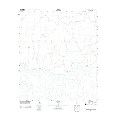
2013 Map of Shafter Canyon
USGS Topo · Published 2013About this map
The Rio Grande snakes through this high-desert landscape along the international boundary between Texas and Coahuila, Mexico. The terrain is defined by dramatic elevation changes at Shafter Canyon and the Shafter Hills, while the small settlement of Loma Vista sits in the northern reaches of the quadrangle. This area was historically shaped by the movement of people and livestock across the river at established points like the Santa Rosa Crossing and El Moro Crossing. Water sources are critical in this arid environment, marked on the sheet by the Blue Water Hole Spring and the drainage systems of Indian Cr and Buena Cr. Connectivity in this isolated region is maintained by the north-south route of Shafter Crossing Rd, which links the uplands to the river basin.
Find a feature on this map
10 named features on this map. Tap any name to fly to it.
Don’t see what you’re looking for? This feature index may not catch every label — zoom into the map to look around manually.
Map Details
Editions of this 2013 Shafter Canyon Map
This is the sole edition of this map. No revisions or reprints were ever made.
Other maps of this area

1918 · Dryden Crossing
USGS Topo · 1:62,500

1943 · Malvado
USGS Topo · 1:62,500

1944 · Malvado
USGS Topo · 1:62,500

1958 · Del Rio
USGS Topo · 1:250,000

1959 · Emory Peak
USGS Topo · 1:250,000

1964 · Del Rio
USGS Topo · 1:250,000

1965 · Emory Peak
USGS Topo · 1:250,000
1979 · Cook Creek North
USGS Topo · 1:24,000
1979 · Cook Creek South
USGS Topo · 1:24,000
1983 · Balcon Creek
USGS Topo · 1:24,000