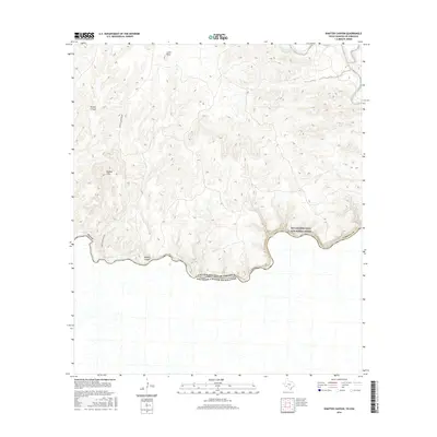
2016 Map of Shafter Canyon
USGS Topo · Published 2016About this map
The Rio Grande carves a sharp, winding international boundary through the Chihuahuan Desert landscape on this 2016 survey, separating Terrell Co, Texas, from the Estados Unidos Mexicanos. This protected stretch, designated as the Rio Grande Wild and Scenic River, is characterized by dramatic elevation shifts and deep drainage systems like Shafter Canyon and Britton Canyon. The terrain rises toward the Shafter Hills and the high point at Loma Vista, while life in this arid environment centers on rare water sources such as Blue Water Hole Spring. Only one primary route, Shafter Crossing Rd, penetrates this section of the river border, highlighting the isolation of the canyons and the seasonal creeks including Indian Creek and Buena Creek that feed the main river channel.
Find a feature on this map
14 named features on this map. Tap any name to fly to it.
Don’t see what you’re looking for? This feature index may not catch every label — zoom into the map to look around manually.
Map Details
Editions of this 2016 Shafter Canyon Map
This is the sole edition of this map. No revisions or reprints were ever made.
Other maps of this area

1918 · Dryden Crossing
USGS Topo · 1:62,500

1943 · Malvado
USGS Topo · 1:62,500

1944 · Malvado
USGS Topo · 1:62,500

1958 · Del Rio
USGS Topo · 1:250,000

1959 · Emory Peak
USGS Topo · 1:250,000

1964 · Del Rio
USGS Topo · 1:250,000

1965 · Emory Peak
USGS Topo · 1:250,000
1979 · Cook Creek North
USGS Topo · 1:24,000
1979 · Cook Creek South
USGS Topo · 1:24,000
1983 · Balcon Creek
USGS Topo · 1:24,000