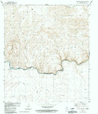
1983 Map of Shafter Canyon
USGS Topo · Published 1991About this map
The Rio Grande Rio Bravo carves a complex international boundary through this arid landscape, where the Shafter Hills and high plateaus meet the river's edge. This 1983 edition, compiled from 1970s field data, captures the remote borderlands of Terrell Co and Coahuila. Near the river's bend, Shafter Crossing and Paso el Moro indicate established points of movement across the water, while the interior is marked by scattered ranching outposts and settlements such as Loma Vista and El Juzgado. North of the river, deep incisions like Shafter Canyon and Britton Canyon define the drainage patterns toward the canyon floor. To the south in Mexico, smaller named localities such as El Encino and Pasta el Sotol appear alongside ephemeral watercourses like El Cibolo. An isolated Landing Strip and the Blue Water Hole serve as critical infrastructure in an area dominated by dry creek beds like Deer Creek and Indian Creek.
Find a feature on this map
28 named features on this map. Tap any name to fly to it.
Don’t see what you’re looking for? This feature index may not catch every label — zoom into the map to look around manually.
Map Details
Editions of this 1983 Shafter Canyon Map
This is the sole edition of this map. No revisions or reprints were ever made.
Other maps of this area

1918 · Dryden Crossing
USGS Topo · 1:62,500

1943 · Malvado
USGS Topo · 1:62,500

1944 · Malvado
USGS Topo · 1:62,500

1958 · Del Rio
USGS Topo · 1:250,000

1959 · Emory Peak
USGS Topo · 1:250,000

1964 · Del Rio
USGS Topo · 1:250,000

1965 · Emory Peak
USGS Topo · 1:250,000
1979 · Cook Creek North
USGS Topo · 1:24,000
1979 · Cook Creek South
USGS Topo · 1:24,000
1983 · Balcon Creek
USGS Topo · 1:24,000