
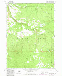
1966 Map of Shake Butte
USGS Topo · Published 1968About this map
The Fremont National Forest spans the border of Lake and Klamath counties, centered around the high elevation of Shake Butte. A Lookout Tower sits atop the butte, overlooking a complex drainage system where the Sycan River winds through the northern half of the quadrangle. Historic movement through this high country is evidenced by the Emigrant Crossing (Site) and various Jeep trails that navigate the plateau.
Find a feature on this map
25 named features on this map. Tap any name to fly to it.
Don’t see what you’re looking for? This feature index may not catch every label — zoom into the map to look around manually.
Map Details
Editions of this 1966 Shake Butte Map
2 editions found
Other maps of this area

1889 · Klamath
USGS Topo · 1:250,000

1894 · Klamath
USGS Topo · 1:250,000

1955 · Klamath Falls
USGS Topo · 1:250,000

1958 · Klamath Falls
USGS Topo · 1:250,000

1960 · Riverbed Butte
USGS Topo · 1:62,500

1960 · Sycan Marsh
USGS Topo · 1:62,500

1966 · Sandhill Crossing
USGS Topo · 1:24,000

1966 · Harvey Creek
USGS Topo · 1:24,000

1966 · Fremont Point
USGS Topo · 1:24,000

1966 · Pole Butte
USGS Topo · 1:24,000