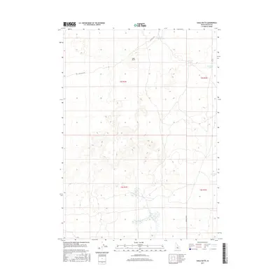
2017 Map of Shale Butte
USGS Topo · Published 2017About this map
Shale Butte dominates this high-desert landscape of Lincoln County, where the topography is defined by subtle volcanic depressions and intermittent water sources. In a region where every permanent or seasonal pool is a critical landmark, small water bodies like Shale Butte Lake, Mustard Lake, and Cottontail Lake provide essential reference points for land management and navigation. The network of primitive roads, including Shale Butte Rd and Kimama Cave Rd, trace routes through the Sagebrush Steppe, likely following historical paths utilized by ranchers and local travelers. The map also delineates the precise township and range boundaries for t5s r22e and t6s r23e, reflecting the orderly sectioning of the public domain in this corner of Idaho.
Find a feature on this map
11 named features on this map. Tap any name to fly to it.
Don’t see what you’re looking for? This feature index may not catch every label — zoom into the map to look around manually.
Map Details
Editions of this 2017 Shale Butte Map
This is the sole edition of this map. No revisions or reprints were ever made.
Other maps of this area

1954 · Pocatello
USGS Topo · 1:250,000

1955 · Idaho Falls
USGS Topo · 1:250,000

1958 · Idaho Falls
USGS Topo · 1:250,000

1958 · Pocatello
USGS Topo · 1:250,000

1972 · Shale Butte
USGS Topo · 1:24,000

1972 · Kimama
USGS Topo · 1:24,000
1972 · Kimama Butte
USGS Topo · 1:24,000

1972 · Community Lake
USGS Topo · 1:24,000

1972 · Laidlaw Lake
USGS Topo · 1:24,000
1972 · Senter
USGS Topo · 1:24,000