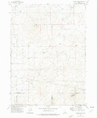
1972 Map of Kimama Butte
USGS Topo · Published 1976About this map
Kimama Butte Lookout Radio Tower stands as the prominent landmark of this high-desert plateau in southern Idaho, marking the triple junction where Lincoln, Jerome, and Minidoka counties meet. The landscape is defined by volcanic features and an arid climate, evidenced by the Kimama Butte Cave and the industrial activity at the Scoria Pit near Sid Butte.
Find a feature on this map
15 named features on this map. Tap any name to fly to it.
Don’t see what you’re looking for? This feature index may not catch every label — zoom into the map to look around manually.
Map Details
Editions of this 1972 Kimama Butte Map
This is the sole edition of this map. No revisions or reprints were ever made.
Other maps of this area

1954 · Pocatello
USGS Topo · 1:250,000

1955 · Twin Falls
USGS Topo · 1:250,000

1958 · Twin Falls
USGS Topo · 1:250,000

1958 · Pocatello
USGS Topo · 1:250,000

1964 · Burley NE
USGS Topo · 1:24,000

1964 · Burley NW
USGS Topo · 1:24,000

1964 · Hazelton NE
USGS Topo · 1:24,000

1971 · Owinza
USGS Topo · 1:24,000
1971 · Owinza Butte
USGS Topo · 1:24,000

1972 · Shale Butte
USGS Topo · 1:24,000