
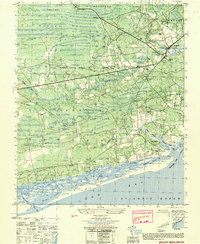
1944 Map of Shallotte
USGS Topo · Published 1944About this map
The coastal village of Shallotte and its surrounding Brunswick County wetlands are documented in this 1944 War Department survey, produced during the height of the Second World War. The landscape is defined by the winding Shallotte River and its numerous tidal tributaries like Little Shallotte River and Shallotte Sound, while the southern edge of the map reveals a rugged shoreline including Hales Beach and the shifting Sand Dunes. Evidence of local infrastructure includes the Shallotte Fire Tower, the Coast Guard Station near the inlet, and a Prison Camp located north of the main settlement. Genealogy and local history researchers will find several landmarks like the Brunswick Co School and family-named markers such as Mintz Cem and Gurganus Cem. The map also preserves traces of older transportation networks, such as the Old RR Grade and the Starboard Road.
Find a feature on this map
67 named features on this map. Tap any name to fly to it.
Don’t see what you’re looking for? This feature index may not catch every label — zoom into the map to look around manually.
Map Details
Editions of this 1944 Shallotte Map
This is the sole edition of this map. No revisions or reprints were ever made.
Other maps of this area

1943 · Little River
USGS Topo · 1:31,680

1943 · Calabash
USGS Topo · 1:31,680

1943 · Freeland
USGS Topo · 1:24,000

1943 · Holden Beach
USGS Topo · 1:24,000

1943 · Exum
USGS Topo · 1:24,000

1943 · Supply
USGS Topo · 1:24,000

1943 · Shallotte
USGS Topo · 1:24,000

1944 · Supply
USGS Topo · 1:31,680

1949 · Georgetown
USGS Topo · 1:250,000
1950 · Shallotte
USGS Topo · 1:25,000