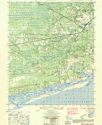
1950 Map of Shallotte
USGS Topo · Published 1951About this map
Shallotte serves as the hub of this coastal Brunswick County landscape during the mid-twentieth century, where the Shallotte River winds southward toward the Atlantic Ocean. The map reveals a community defined by its proximity to the water, featuring the Intracoastal Waterway cutting behind Hales Beach and the busy Shallotte Inlet. Cultural landmarks like the Brunswick Co School and several rural houses of worship, including St Marks Ch and New Hope Church, suggest a settled, traditional coastal economy.
Find a feature on this map
60 named features on this map. Tap any name to fly to it.
Don’t see what you’re looking for? This feature index may not catch every label — zoom into the map to look around manually.
Map Details
Editions of this 1950 Shallotte Map
This is the sole edition of this map. No revisions or reprints were ever made.
Other maps of this area

1943 · Little River
USGS Topo · 1:31,680

1943 · Calabash
USGS Topo · 1:31,680

1943 · Freeland
USGS Topo · 1:24,000

1943 · Holden Beach
USGS Topo · 1:24,000

1943 · Exum
USGS Topo · 1:24,000

1943 · Supply
USGS Topo · 1:24,000

1943 · Shallotte
USGS Topo · 1:24,000

1944 · Supply
USGS Topo · 1:31,680

1944 · Shallotte
USGS Topo · 1:31,680

1949 · Georgetown
USGS Topo · 1:250,000