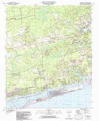
1990 Map of Shallotte
USGS Topo · Published 1991About this map
Shallotte serves as the inland anchor for this coastal Brunswick County region, where the Shallotte River winds through vast wetlands like Saw Pit Swamp and Middle Swamp toward the Atlantic Ocean. The landscape reflects a mix of maritime development and deep-rooted rural history, with smaller inland communities such as Russtown and Seaside providing a contrast to the planned expansion of Ocean Isle Beach. This barrier island community is heavily defined by its proximity to the Intracoastal Waterway and the Ocean Isle Beach Airport.
Find a feature on this map
51 named features on this map. Tap any name to fly to it.
Don’t see what you’re looking for? This feature index may not catch every label — zoom into the map to look around manually.
Map Details
Editions of this 1990 Shallotte Map
This is the sole edition of this map. No revisions or reprints were ever made.
Other maps of this area

1943 · Little River
USGS Topo · 1:31,680

1943 · Calabash
USGS Topo · 1:31,680

1943 · Freeland
USGS Topo · 1:24,000

1943 · Holden Beach
USGS Topo · 1:24,000

1943 · Exum
USGS Topo · 1:24,000

1943 · Supply
USGS Topo · 1:24,000

1943 · Shallotte
USGS Topo · 1:24,000

1944 · Supply
USGS Topo · 1:31,680

1944 · Shallotte
USGS Topo · 1:31,680

1949 · Georgetown
USGS Topo · 1:250,000