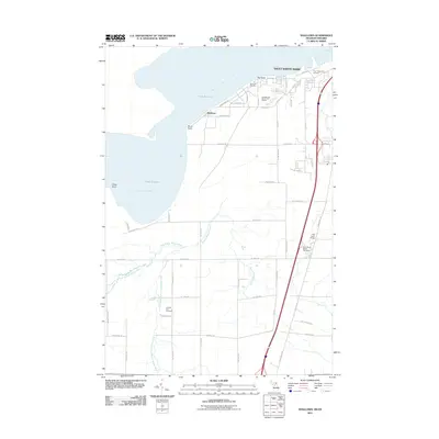
2011 Map of Shallows
USGS Topo · Published 2011About this map
Sault Sainte Marie and the surrounding shoreline of Lake Superior define this northern Michigan landscape, where the Saint Marys River meets the industrial and recreational waterfront. This survey highlights the transition from urban infrastructure, such as The C Reiss Coal Company and the Sault Sainte Marie Rest Area, to the semi-rural outskirts characterized by landmarks like the Pine Grove Grange. Further inland, the terrain is marked by a complex network of waterways, including Beaver Meadow Creek and the East Branch Waiska River, which drain into Izank Walton Bay. Local historical and community sites are well-documented, from the Sherman Park Zoo and Tanglewood Marsh Golf Course near the coast to the more secluded Cottage Park Cemetery. The map captures the grid-like road expansion pushing south from the river into the wooded and marshy environments near Shallows.
Find a feature on this map
58 named features on this map. Tap any name to fly to it.
Don’t see what you’re looking for? This feature index may not catch every label — zoom into the map to look around manually.
Map Details
Editions of this 2011 Shallows Map
This is the sole edition of this map. No revisions or reprints were ever made.
Other maps of this area

1913 · Sault Sainte Marie
USGS Topo · 1:62,500

1941 · Sault Sainte Marie
USGS Topo · 1:63,360

1941 · Brimley
USGS Topo · 1:63,360

1951 · Shallows
USGS Topo · 1:24,000

1951 · Kinross
USGS Topo · 1:24,000

1951 · Dafter
USGS Topo · 1:24,000

1951 · Barbeau
USGS Topo · 1:24,000

1951 · Brimley
USGS Topo · 1:62,500

1951 · Sault Ste. Marie
USGS Topo · 1:62,500

1951 · Brimley
USGS Topo · 1:24,000