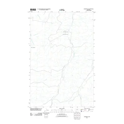
2011 Map of Shambo SE
USGS Topo · Published 2011About this map
Mount Reynolds stands as a prominent elevation in this northern Montana landscape, anchoring a complex system of drainage and ranch roads. The terrain is defined by the carved paths of War Bonnet Coulee and Henrys Basin Coulee, which channel seasonal water toward the larger creek systems. This map shows a sparsely populated area where transport is limited to dirt and gravel routes like Sucker Creek Rd and Clear Creek Rd, tracing the low ground between ridges. The hydrography of the region is notably intricate, with Bullhook Creek and Little Boxelder Creek branching through the hills, providing the critical water sources that likely dictated the placement of the early livestock ranges and local homesteads in this part of Hill County.
Find a feature on this map
12 named features on this map. Tap any name to fly to it.
Don’t see what you’re looking for? This feature index may not catch every label — zoom into the map to look around manually.
Map Details
Editions of this 2011 Shambo SE Map
This is the sole edition of this map. No revisions or reprints were ever made.
Other maps of this area

1953 · Havre
USGS Topo · 1:250,000

1956 · Maddux
USGS Topo · 1:62,500

1956 · Lloyd
USGS Topo · 1:62,500

1957 · Havre
USGS Topo · 1:250,000

1958 · Havre
USGS Topo · 1:250,000

1959 · Warrick
USGS Topo · 1:62,500

1959 · Shambo
USGS Topo · 1:62,500
1984 · Bearpaw Lake
USGS Topo · 1:24,000
1984 · Shambo NE
USGS Topo · 1:24,000

1984 · Big John Butte
USGS Topo · 1:24,000