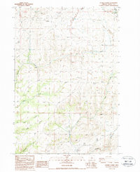
1987 Map of Shaniko Summit
USGS Topo · Published 1988About this map
Shaniko Summit rises as a prominent landmark in this high plateau region of Wasco County, Oregon, during the late 20th century. The landscape is defined by a network of deep drainage systems, including Deep Canyon, Chain Canyon, and the appropriately named Deadman Canyon in the southwest. Settlement in this arid stretch is sparse, anchored by the town of Shaniko in the northeast corner and smaller holdings such as Rooper Ranch. The map reveals a reliance on essential water sources, indicated by numerous unnamed Springs and named flows like Ward Creek and Cottonwood Creek. A solitary Pipeline cuts across the northern townships, contrasting with the many 4wd tracks that serve as the primary means of navigating the canyons and hills. Local landmarks like Courthouse Rock and Cross Hill provide orientation points for researchers and genealogists tracing the pastoral and ranching history of this high-desert territory.
Find a feature on this map
25 named features on this map. Tap any name to fly to it.
Don’t see what you’re looking for? This feature index may not catch every label — zoom into the map to look around manually.
Map Details
Editions of this 1987 Shaniko Summit Map
This is the sole edition of this map. No revisions or reprints were ever made.
Other maps of this area

1953 · The Dalles
USGS Topo · 1:250,000

1955 · Bend
USGS Topo · 1:250,000

1956 · The Dalles
USGS Topo · 1:250,000

1957 · Bend
USGS Topo · 1:250,000

1957 · The Dalles
USGS Topo · 1:250,000

1958 · Bend
USGS Topo · 1:250,000

1966 · Antelope
USGS Topo · 1:62,500

1966 · Willowdale
USGS Topo · 1:62,500

1970 · Macken Canyon
USGS Topo · 1:24,000
1971 · Criterion
USGS Topo · 1:24,000