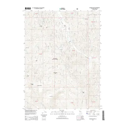
2015 Map of Shannon Butte
USGS Topo · Published 2015About this map
Six Rivers National Forest blankets this mountainous reach of the California Coast Ranges, where the headwaters of the Mad River and the N Fork Eel River carve deep into the landscape. This area is characterized by several family-named landmarks and homestead-style locations including Crabtree Place, Shannon Place, and Russ Place, which point to the region's history of high-country ranching or settlement. The terrain is marked by prominent peaks and ridges, such as Smith Peak and Mad River Ridge, rising above canyon-bound waterways like Yellowjacket Cr and Littlefield Cr. This 2015 topography also shows the Ruth Airport positioned along the river valley, a modern utility point in a region otherwise dominated by forest service routes like Forest Rte 2512 and natural features like Beaver Slide and Perrys Knob.
Find a feature on this map
59 named features on this map. Tap any name to fly to it.
Don’t see what you’re looking for? This feature index may not catch every label — zoom into the map to look around manually.
Map Details
Editions of this 2015 Shannon Butte Map
This is the sole edition of this map. No revisions or reprints were ever made.
Other maps of this area

1918 · Anada
USGS Topo · 1:62,500

1921 · Hoaglin
USGS Topo · 1:62,500

1922 · Island Mountain
USGS Topo · 1:62,500

1931 · Hoaglin
USGS Topo · 1:96,000

1935 · Hoaglin
USGS Topo · 1:125,000

1953 · Blackrock Mtn
USGS Topo · 1:62,500

1954 · Pickett Peak
USGS Topo · 1:62,500

1954 · Dubakella Mtn
USGS Topo · 1:62,500

1954 · Blackrock Mtn
USGS Topo · 1:62,500
1955 · Kettenpom
USGS Topo · 1:62,500