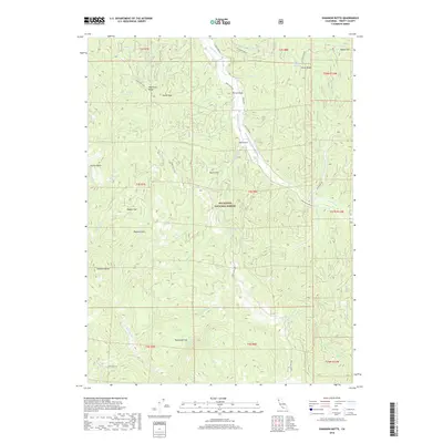
2018 Map of Shannon Butte
USGS Topo · Published 2018About this map
Six Rivers National Forest dominates this Trinity County landscape, where the headwaters of the Mad River and the N Fork Eel River carve through the high terrain. The map details a network of Forest Service routes, including Long Ridge Rd and Mad River Rd, which connect remote clearings such as Packwood Flat and Raglan Flat. The presence of the Ruth Airport near the center of the sheet indicates the importance of aerial access in this heavily timbered region. Prominent peaks and ridges, such as Smith Peak, Shannon Butte, and Horse Ridge, define the complex drainage patterns of creeks like Dutchman Cr and Yellowjacket Cr. The topographic detail preserves the locations of numerous mountain springs, including Surveyor Spring and Water Trough Spring, essential landmarks for those navigating the backcountry of northern California.
Find a feature on this map
54 named features on this map. Tap any name to fly to it.
Don’t see what you’re looking for? This feature index may not catch every label — zoom into the map to look around manually.
Map Details
Editions of this 2018 Shannon Butte Map
This is the sole edition of this map. No revisions or reprints were ever made.
Other maps of this area

1918 · Anada
USGS Topo · 1:62,500

1921 · Hoaglin
USGS Topo · 1:62,500

1922 · Island Mountain
USGS Topo · 1:62,500

1931 · Hoaglin
USGS Topo · 1:96,000

1935 · Hoaglin
USGS Topo · 1:125,000

1953 · Blackrock Mtn
USGS Topo · 1:62,500

1954 · Pickett Peak
USGS Topo · 1:62,500

1954 · Dubakella Mtn
USGS Topo · 1:62,500

1954 · Blackrock Mtn
USGS Topo · 1:62,500
1955 · Kettenpom
USGS Topo · 1:62,500