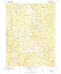
1967 Map of Shannon Butte
USGS Topo · Published 1969About this map
The Mad River carves through this northern California landscape within the Six Rivers National Forest, shaping a terrain defined by high ridges and isolated ranching outposts. During the late 1960s, the area's infrastructure supported both aviation at the Ruth County Airport and livestock operations at sites like Gilman Ranch and Double A Ranch. The map reveals a pattern of mid-century land use where named homesteads such as Yellowjacket Place, Shannon Place, and Crabtree Place were scattered across the flats and gulches, often near reliable water sources like Tub Spring or Water Trough Spring. Mining interest is represented by the Barry Creek Mine, while timber and transit are evidenced by a network of jeep trails and the Wildwood Road. In the south, the headwaters of the North Fork Eel River begin their descent, marking a significant hydrologic divide near Packwood Flat.
Find a feature on this map
65 named features on this map. Tap any name to fly to it.
Don’t see what you’re looking for? This feature index may not catch every label — zoom into the map to look around manually.
Map Details
Editions of this 1967 Shannon Butte Map
This is the sole edition of this map. No revisions or reprints were ever made.
Other maps of this area

1918 · Anada
USGS Topo · 1:62,500

1921 · Hoaglin
USGS Topo · 1:62,500

1922 · Island Mountain
USGS Topo · 1:62,500

1931 · Hoaglin
USGS Topo · 1:96,000

1935 · Hoaglin
USGS Topo · 1:125,000

1953 · Blackrock Mtn
USGS Topo · 1:62,500

1954 · Pickett Peak
USGS Topo · 1:62,500

1954 · Dubakella Mtn
USGS Topo · 1:62,500

1954 · Blackrock Mtn
USGS Topo · 1:62,500
1955 · Kettenpom
USGS Topo · 1:62,500