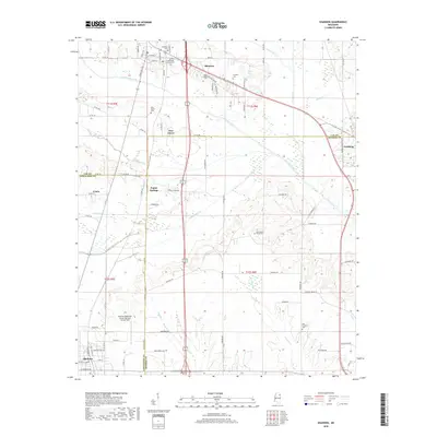
2018 Map of Shannon
USGS Topo · Published 2018About this map
Shannon and the surrounding borderlands of Lee, Chickasaw, and Monroe Counties are defined by a complex drainage network that has long shaped North Mississippi settlement. Waterways like Chiwapa Creek, Tallabinnela Creek, and Tubbalubba Cr carve through the landscape, dictating the placement of early road networks such as Co RD 506 and Old Hwy 45. For genealogists, the map is particularly detailed regarding local burial grounds, including the Whiteside Family Cem and Dotys Chapel Cem, which offer physical links to the area's pioneer families.
Find a feature on this map
92 named features on this map. Tap any name to fly to it.
Don’t see what you’re looking for? This feature index may not catch every label — zoom into the map to look around manually.
Map Details
Editions of this 2018 Shannon Map
This is the sole edition of this map. No revisions or reprints were ever made.
Other maps of this area

1953 · West Point
USGS Topo · 1:250,000

1956 · Tupelo
USGS Topo · 1:250,000

1958 · Tupelo
USGS Topo · 1:250,000

1958 · West Point
USGS Topo · 1:250,000

1959 · Van Vleet
USGS Topo · 1:62,500

1963 · West Point
USGS Topo · 1:250,000

1965 · Egypt
USGS Topo · 1:24,000

1966 · Shannon
USGS Topo · 1:24,000

1966 · Wren
USGS Topo · 1:24,000
1966 · Nettleton
USGS Topo · 1:24,000