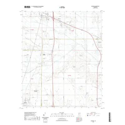
2020 Map of Shannon
USGS Topo · Published 2020About this map
The town of Shannon and the northern outskirts of Okolona anchor this landscape where three Mississippi counties—Lee, Chickasaw, and Monroe—converge. Small family and community cemeteries are frequent markers across the terrain, including the Whiteside Family Cem, Doty Chapel Cem, and New Prospect Cem. The drainage patterns of Chiwapa Creek and Tallabinnela Creek define the low-lying areas between the small settlements of Pine Grove and Poplar Springs. In the southern portion of the map, the Okolona Municipal Airport-Richard Stovall Field occupies a broad tract of land just east of the city's residential streets, like W Monroe Ave and E Main ST. This modern survey reflects the enduring rural structure of the region, where legacy farm roads like Camargo Rd and Okolona Rd connect historic crossroads and parish burial grounds.
Find a feature on this map
86 named features on this map. Tap any name to fly to it.
Don’t see what you’re looking for? This feature index may not catch every label — zoom into the map to look around manually.
Map Details
Editions of this 2020 Shannon Map
This is the sole edition of this map. No revisions or reprints were ever made.
Other maps of this area

1953 · West Point
USGS Topo · 1:250,000

1956 · Tupelo
USGS Topo · 1:250,000

1958 · Tupelo
USGS Topo · 1:250,000

1958 · West Point
USGS Topo · 1:250,000

1959 · Van Vleet
USGS Topo · 1:62,500

1963 · West Point
USGS Topo · 1:250,000

1965 · Egypt
USGS Topo · 1:24,000

1966 · Shannon
USGS Topo · 1:24,000

1966 · Wren
USGS Topo · 1:24,000
1966 · Nettleton
USGS Topo · 1:24,000