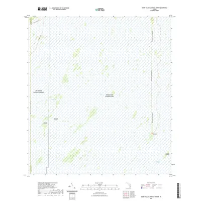
2021 Map of Shark Valley Lookout Tower
USGS Topo · Published 2021About this map
Everglades National Park and Big Cypress National Preserve meet in this 2021 study of the South Florida wetlands. The landscape is defined by the vast Shark River Slough and East Slough, where slight elevations in the limestone bedrock create tree islands known as hammocks. Significant natural landmarks like Iron Pot Hammock, Dogwood Hammock, and Seagrape Hammock provide critical habitat amidst the sawgrass marsh. Human access is delineated by the Shark Valley Tram Loop Road Trl, leading to the prominent Shark Valley Lookout Tower, which serves as a central point for environmental observation. The map also records the jurisdictional boundary where Monroe and Miami-Dade counties intersect, alongside terrain features like Rattlesnake Ridge and the Boundary Line Trl.
Find a feature on this map
13 named features on this map. Tap any name to fly to it.
Don’t see what you’re looking for? This feature index may not catch every label — zoom into the map to look around manually.
Map Details
Editions of this 2021 Shark Valley Lookout Tower Map
This is the sole edition of this map. No revisions or reprints were ever made.
Other maps of this area

1956 · Miami
USGS Topo · 1:250,000

1958 · Miami
USGS Topo · 1:250,000

1972 · Shark Valley Lookout Tower
USGS Topo · 1:24,000

1972 · Lostmans Trail
USGS Topo · 1:24,000

1972 · Chekika Island
USGS Topo · 1:24,000

1972 · Panther Mound
USGS Topo · 1:24,000

1972 · Indian Camp Creek
USGS Topo · 1:24,000
1972 · Black Hammock
USGS Topo · 1:24,000

1973 · Fortymile Bend
USGS Topo · 1:24,000

1973 · Fiftymile Bend
USGS Topo · 1:24,000