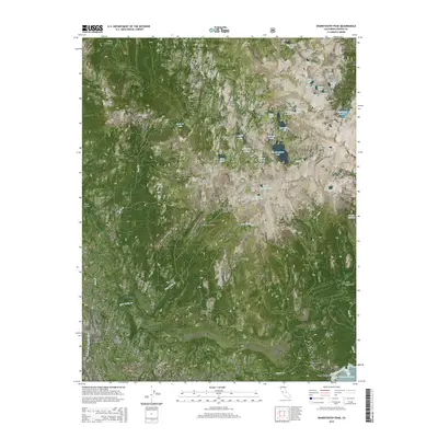
2015 Map of Sharktooth Peak
USGS Topo · Published 2015About this map
Sharktooth Peak stands as the literal and figurative high point of this high-altitude landscape within the Sierra National Forest, where the complex hydrology of the Sierra Nevada is on full display. The terrain is characterized by an extensive network of glacial lakes and meadows, including the clusters of Margaret Lakes and smaller, colorfully named bodies like Useless Lake, Beetlebug Lake, and Bathtub Lake. The Silver Divide serves as a major topographical spine, separating various drainage basins that feed into Silver Creek and the South Fork San Joaquin River in the southwestern corner. Researchers will find a pristine wilderness environment where landmarks like the Cockscomb and Arch Rock provide navigation points across a roadless expanse. Notable for its lack of human infrastructure, the map instead highlights significant alpine meadows such as Tule Meadow, Hedrick Meadow, and Onion Spring Meadow, which indicate traditional grazing or wildlife areas.
Find a feature on this map
52 named features on this map. Tap any name to fly to it.
Don’t see what you’re looking for? This feature index may not catch every label — zoom into the map to look around manually.
Map Details
Editions of this 2015 Sharktooth Peak Map
This is the sole edition of this map. No revisions or reprints were ever made.
Other maps of this area

1901 · Mt. Lyell
USGS Topo · 1:125,000

1904 · Kaiser
USGS Topo · 1:125,000

1912 · Mt. Goddard
USGS Topo · 1:125,000

1914 · Mt. Morrison
USGS Topo · 1:125,000

1947 · Mariposa
USGS Topo · 1:250,000

1948 · Mariposa
USGS Topo · 1:250,000

1953 · Mt. Morrison
USGS Topo · 1:62,500

1953 · Mt Abbot
USGS Topo · 1:62,500

1953 · Devils Postpile
USGS Topo · 1:62,500

1953 · Kaiser Peak
USGS Topo · 1:62,500